Features
Everything here is in the free online map unless it says desktop app. Features marked Premium are in the desktop app: they work free for 30 days, then need a licence key. The manual explains every setting.
Propagation map · Band predictions · Gray line, MUF and aurora · DX cluster map · DXpeditions · Rotators and CAT
A live HF propagation map
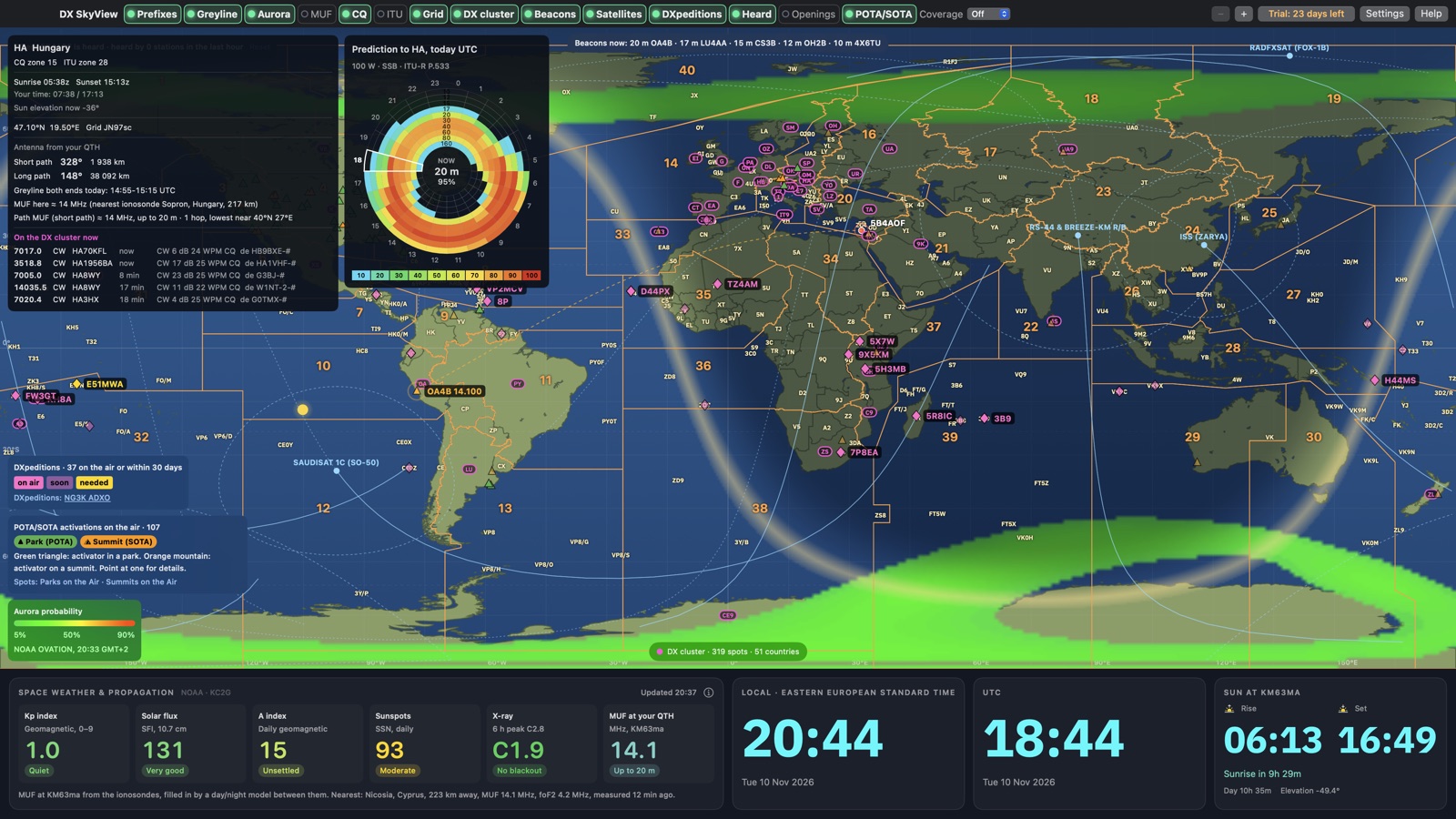
DX SkyView shows today's band conditions on one world map that updates by itself: day and night every minute, the twilight band, the MUF from live ionosondes, the NOAA aurora forecast, space weather and X-ray from NOAA SWPC, and DX cluster spots. Point at any country and the info box shows its CQ and ITU zones, grid square, sunrise and sunset, short and long path bearing and distance from your QTH, aurora chance, the MUF on the path and its cluster spots.
The Digital layer shows FT8 and FT4 live from PSK Reporter: every station on the air now, what the stations near you decode on each band (stations, countries, the farthest one) and lines showing who decodes whom. In the desktop app it is for your own station, and countries you still need get a gold ring and an alert.
It also shows NCDXF beacons, satellites, POTA and SOTA activations, and, in the desktop app, "Where am I heard" from PSK Reporter and the Reverse Beacon Network. It runs in a browser on a PC, tablet or phone, or as a desktop app for Windows, Mac and Linux.
Band predictions with ITU-R P.533
For any country more than 300 km away, a 24-hour prediction wheel shows the chance of a contact on each band, hour by hour, for this month. The centre shows the best band now. The coverage map shows where one band reaches from your station. (Premium, desktop app)
Predictions use the ITU's own ITU-R P.533 and P.372 software and data from ITU-R Study Group 3, for your locator, power and antennas. A quick model is available too. Predictions are probabilities, not guarantees, so DX SkyView puts them next to live data: the MUF map, the cluster and Heard.
Gray line, MUF map and aurora
Gray line: night is darker and the twilight band glows; low bands often open along it. The greyline planner gives the UTC times today when both you and the other station are in twilight.
MUF map: the highest usable frequency for a 3000 km hop, from live ionosondes plus a model. Labelled lines mark the band edges, so inside the 14 line 20 m is open. The info box works out the MUF along your path.
Aurora: NOAA's OVATION forecast of the chance of aurora. Paths through it are weak and fluttery.
A DX cluster map
Spotted countries blink on the map: the ones you still need blink gold, and watched callsigns green. Point at one for the frequency, mode, call, age and comment. Spots refresh every minute from the node you choose, with filters for modes and bands.
In the desktop app, My DXCC reads your log (also from LoTW and Club Log), so the map knows which countries you need. Alerts and band opening alerts tell you when one shows up. (Premium, desktop app)
DXpeditions on the map
Announced DX operations appear as diamonds at their country: bright pink when on the air now, faded pink when starting within 30 days, gold for a country you still need. Point at one for the callsign, dates, bands, QSL route, and the bearing and distance from your QTH. Then use the prediction wheel for the best time to call.
The list comes from NG3K's Announced DX Operations (ADXO), used with the kind permission of Bill NG3K.
Rotator and radio control
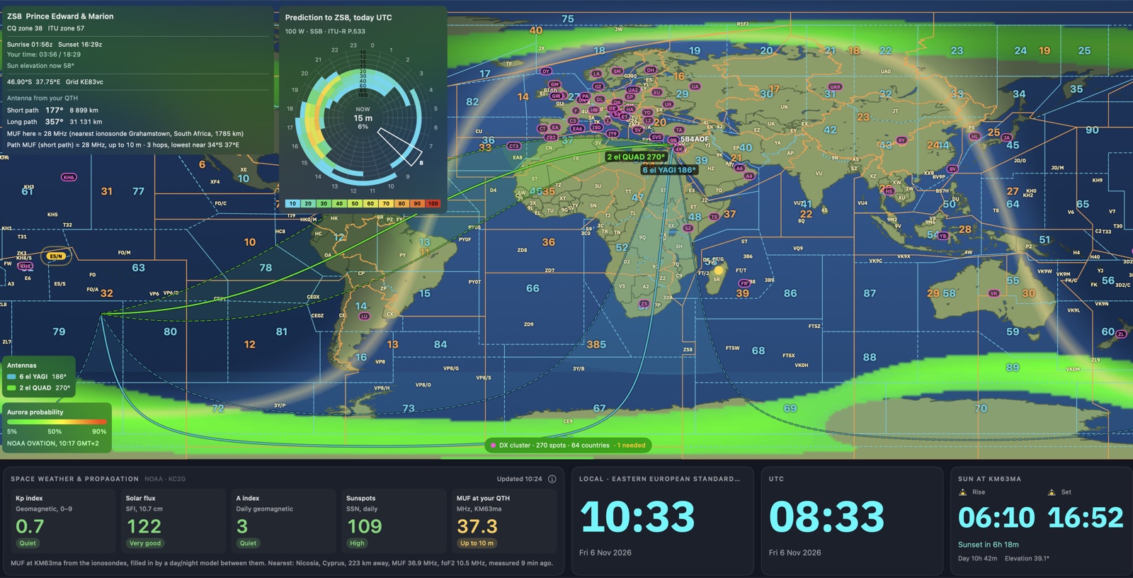
Beam heading and rotators: each antenna's beam is drawn on the map. Right-click a country, spot or place and choose the antenna to turn there, or type a heading. Supported: Yaesu GS-232A/B (G-450, G-800, G-1000, G-2800 and compatible interfaces), Prosistel D and F, and Hamlib rotctld. (Premium, desktop app)
Radio control (CAT): the map shows your radio's frequency and mode, and a click on a spot or a POTA/SOTA activator tunes the radio, sets the mode and can turn the antenna too. (Premium, desktop app)
- Finds your set-up by itself: tick Use radio control and DX SkyView finds the logger or radio program that has your radio (N1MM Logger+, DXLog, N3FJP, MacLoggerDX, DXLab Commander, Ham Radio Deluxe, OmniRig, flrig, rigctld), or the radio itself on its USB cable, with model, port and speed. Nothing to choose. It never keys your radio.
- Two radios (SO2R): with N1MM Logger+ or DXLog the map shows both radios, and a click on a spot tunes the radio already on that band.
- Share the radio with WSJT-X and your logger: DX SkyView holds the radio and passes it on at 127.0.0.1:4532, so WSJT-X and loggers with a Hamlib radio choice use it at the same time.
- Logger link: N1MM Logger+, DXLog, N3FJP, MacLoggerDX, DXLab Commander, Ham Radio Deluxe and OmniRig keep the radio; the map reads the frequency and tunes through them.
- Alerts on your phone: a watched callsign, a needed country or a DXpedition on the cluster also reaches your phone, through the free ntfy app or Telegram.
- Your own WSJT-X decodes on the map: every station your radio decodes, as a diamond with a line from your QTH, next to what PSK Reporter shows.
- Follow the radio: the coverage map, the beacon band, the cluster and Digital show the band the radio is on.
- Also works with Hamlib rigctld and flrig. Hamlib is free software (LGPL).
Try it
Open the live map, free Download for Windows, Mac or Linux
Questions? See the FAQ.